Risk assessment (Oil)
Risk assessment (Oil)
Assessments of changing risks from oil accidents and chronic pollution represent another issue. A toolbox called PELLETS-2D including an oil chemistry model was developed to allow for offline Lagrangian transport calculations based on ocean currents derived from coastDat. The toolbox was successfully applied to both, assessing risks from accidental and chronic oil pollution along the German North Sea coast.
Chronic pollution does mostly not correlate with recorded ship accidents but is caused by illegal oil dumping such as tank washing or the disposal of bilge water, for instance. The absolute amount of oil spilled is difficult to estimate as discharges often go undetected by aerial surveillance. Time and again, either corpses of oil-contaminated birds are found along the German North Sea coast or pollution is directly observed in certain coastal areas.
To what extent pollution affects coastal areas depends on winds and currents prevailing at the time of the incident. The coastDat database provides a detailed description of these parameters during the past decades. Using PELETS-2D this information was used to reconstruct drift paths of hypothetical oil slicks assumed to be released continuously along major shipping routes in the German Bight. Performing a large number of such simulations allows for a general assessment of how the exposure of the German coast to chronic oil pollution varies in time and between different coastal areas.
Chrastansky and Callies (2009) used PELETS-2D to establish drift statistics for the period 1958-2003. Assuming a constant frequency of oil releases, a large number of simulations (hypothetical oil spills) at different locations was initialized with constant time lags (28 h) between them. Subdividing the German North Sea coast into a couple of receptor regions, results provided a proper description of both the mean risk exposure of different coastal areas and corresponding variability. Chrastansky et al. (2009) were successful in using these data for a more in depth interpretation of monitoring data.
Chrastansky and Callies (2011) summarized the results from the above study in terms of probabilistic relationships that describe spatial dependences and sensitivities between parameters addressed in the study. The mutual interactions were represented using Bayesian Network (BN) technology. The resulting BN is accessible via an interactive graphical user interface and allows for an interactive exploration of how simulated results depend on parameters like location of the spill, wind direction, wind speed, season of the year, or assumed half-life of the hypothetical pollutant.

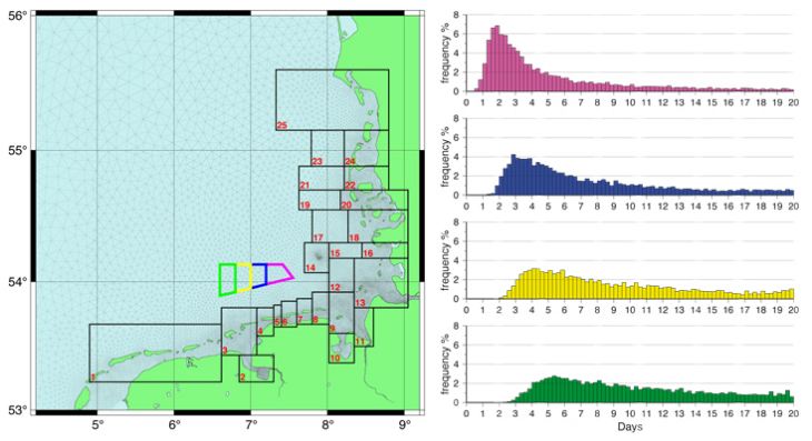
Figure 1: Distribution of simulated travel times for passive tracer particles that reach box 14 after having been released within one of the four different colour coded source regions in the left panel. Results are based on 13615 simulations initialized within the years 1958-1999. Graph: Hereon/ Ulrich Callies
Figure 1 gives an example of how a large number of simulations started at different times within a long period of several decades results in a sound statistical estimate of tracer particle travel times, for instance. Such ensemble simulations covering all realistic weather conditions can provide important information that supports the assessment of efficient countermeasures considered in the context of risk studies.
Lagrangian transport calculations: PELETS-2D
PELETS-2D is a toolbox written in Fortran 90 and linked to coastDat that allows for offline Lagrangian transport calculations (i.e. particle tracking) based on 2D current fields stored on at least an hourly basis. The toolbox was developed for its use in connection with model based re-analyses of past atmospheric and marine conditions. Depending on a study's objective, drift simulations may be performed either forward or backward in time. For substances drifting at the water surface an extra wind drift may be taken into account. PELETS-2D was developed for applications on unstructured triangular grids, but interfaces to a couple of hydrodynamic models on regular grids are also available (cf. Callies et al. 2011). If hydrodynamic models provide 3D current fields, PELETS may refer to either vertical mean velocities or velocities from the top layer. PELETS-2D supports dealing with large ensembles of particle cloud simulations. Simulations may be initialized, for instance, with constant time lags so as to cover different atmospheric conditions with an implicit weighting according to the frequency of their occurrence in long-term re-analyses. Alternatively, simulations may be scheduled to meet special requirements of biological studies (e.g. the selection of specific seasons), for instance. PELETS-2D provides a couple of general tools for the evaluation of such large ensembles, including the generation of composites and principal component analysis.
